| Karnala
|
| At a Glance |
| Trek |
Karnala |
| Alias |
-- |
| Type |
Hill Fort |
| District |
Raigad |
| Height above mean sea
level |
~ 1410 ft (~ 429 m) |
| Base
Village |
-- |
| Minimum
Duration |
1 day |
| Region |
-- |
| Transport |
Kalyan to Panvel (road, 35
km)- Karnala base (road, 12 km) |
| Time to
reach the top |
1 1/2 to 2
hrs from base |
| Water
Availability |
Water cisterns are available at the top |
| Best
season to visit |
Any time except
summer |
| Sights to
visit |
Darwaja, fortification, Buruj's etc |
| Difficulty Rating |
Simple |
| Shelter |
Cave at the top, govenrnment rooms
(Forest dept) at the
base. | |
| Location |
Karnala is situated about 12 km from Panvel. Karnala fort actually is a part of
"Karnala Bird Sanctuary" which hosts varirty of birds.
|
| |
| Precaution |
| 1. Beehives are often seen on the pinnacle and Honey bee's, if disturbed, can be troublesome.
|
| |
| Sight Seeing |
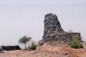
1. This is a very small fort, which probably was built to keep a watch on surrounding Kokan region. It's peculiar, thumb shaped pinnacle is a attraction for all.
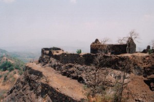
2. Fort has 2-3 Darwaja's (Gates) in a good condition and bastions as well.
3. Fortification is in good condition in some parts of the fort.
|
| |
| Note |
| All references regarding duration
of trek and transport are given with respect to Kalyan, which is
about 50 km north-east of Mumbai. |
| Contact |
| cdeepan@gmail.com Deepan Ashok Choudhary |
| abhijit.avalaskar@gmail.com Abhijit Ulhas Avalaskar |
| Last updated on : 1st Dec 2005 |
